
A consolidation of known proposals for the period 1989 through 2050 and beyond, showing possible future linkages, redevelopment and new development directions at all cardinal directions.
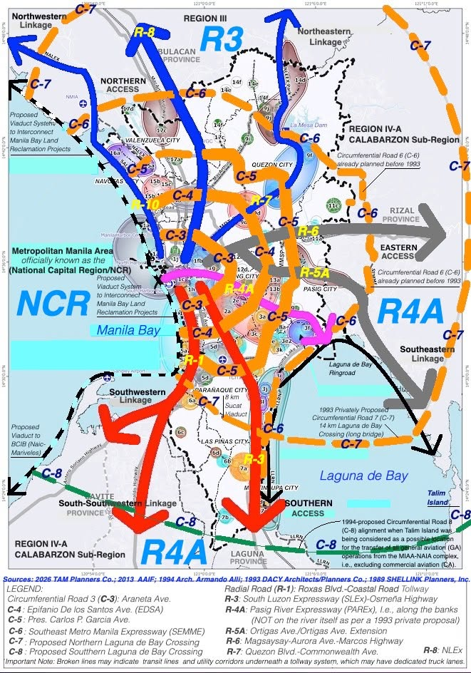
This version shows the existing major arterial roads, i.e., both radial roads, which are inter-regional linkages, and circumferential roads, which are mainly intra-regional linkages. The circumferential roads (C-3, C-4, C-5 and the C-5 extension to the New Manila International Airport (NMIA) in Bulacan Province, plus the proposed C-6 and the C-6 extension to NMIA Bulacan) may be supplemented by the proposed C-7 starting at Sucat Road and the Coastal Road (R-1), crossing 14 kilometers (km) of Laguna de Bay to Rizal Province (i.e., using a shallow water variant of the long bridge technology employed for the ADB-funded 32-km Bataan-Cavite Interlink Bridge (BCIB) Project), with the C-7 eventually ending at the area north of NMIA Bulacan.
Another Laguna de Bay crossing, i.e., Circumferential Road 8 (C-8), can still be introduced further south, but it may essentially service the CALABARZON Sub-Region, Rizal Province in particular (since it has long lagged in CALABARZON development). The C-8 crossing was first proposed in 1994, when Talim Island was being considered as a possible location for the transfer of all general aviation (GA) operations from the MIAA-NAIA complex (excluding commercial aviation, or CA), in order to make room for the then proposed Manila International Cargo Terminal (MICT) Complex. The MICT Complex was not built, but its elevated expressway component around the NAIA Complex (and linking to the Coastal Road, R-1) was the one that was built and operated.
These possible future linkages (the C-7 and C-8 lake crossings) can offer potentially viable inter-regional connections to Region III (R3) and the CALABARZON Sub-Region of Region IV-A (R4A). Both lake crossing proposals are premised on the technical and environmental feasibility of shallow lake crossings (i.e., considering the presence of 2 to 3 calderas, or collapsed extinct or dormant underwater volcanoes, on the east side of Talim Island).
The image also includes a version of the proposed Pasig River Expressway (PAREx) at MMA center, but as per a 1993 private sector proposal, said tollway system shall not use the waterway itself but only utilize the air and land rights along the legal easement (LE) and a portion of the air rights alongside the banks (via a cantilevered structure), i.e., along the south bank of the Pasig River from Roxas Blvd. (Radial Road 1) to an area east of the Nagtahan Bridge, and thereafter along the north bank of the Pasig River from east of the Nagtahan Bridge area all the way to Laguna de Bay, where it may eventually intersect with the proposed Southeast Metropolitan Manila Expressway, i.e., the pre-1993 Circumferential Road 6 (C-6) Project.
A key proposal is the viaduct system at Manila Bay to interconnect all proposed land reclamation projects, initially from the Bulacan area (of R3) all the way to the Cavite coastal area (R4A).
Please note that all proposed tollway alignments (as shown in broken lines, including SEMME and potentially including PAREx) may potentially include a medium-haul transit line and a utility corridor right below the tollway system, which must have dedicated truck lanes. Thank You.
Sources: 2026 TAM Planners Co. (TAMpc); 2013 Architecture Advocacy International Foundation (AAIF), Inc.; 1994 Arch. Armando Allí (AAA); 1993 DACY Architects/Planners Co. (DACYapc); and 1989 SHELLINK Planners, Inc. (SPI)
